Mission products as they are measured by MERLIN
Level 0 (L0) data consist of raw data containing the backscattered signals for each individual laser shot pair, auxiliary data, and some geometric information (latitude, longitude) in a chronological data sequence. The ordering of the data and its cutting into individual products of one orbit is done in this L0 processing step. This data wil only be available on request to scientific users only. For this, please contact us.
Level 1a (L1a) products consist of vertically resolved, pulse energy corrected lidar data on a shot-by-shot basis. The processing steps include removal of background signals and performing minor non-linearity corrections. The vertical sampling of this product is 2 m below an altitude of about 3 km. This corresponds to the length of the range bin given by the speed of the Analog-Digital-Converter (ADC), which is 75 MHz. It is 50 m (sum of 25 range bins) between 3 and 20 km and 200 m (sum of 100 range bins) between 20 and 40 km, respectively. The vertical resolution of the lidar signals (e.g., the length of uncorrelated vertical backscatter signals) is 30 m, which is given by the limited bandwidth of the detection electronic chain. L1a product will be complemented by the ensemble of parameters that are necessary to go from L0 data to L1a product. This complement will be gathered as the level 1p data and distributed to experts on request
Expected Performance
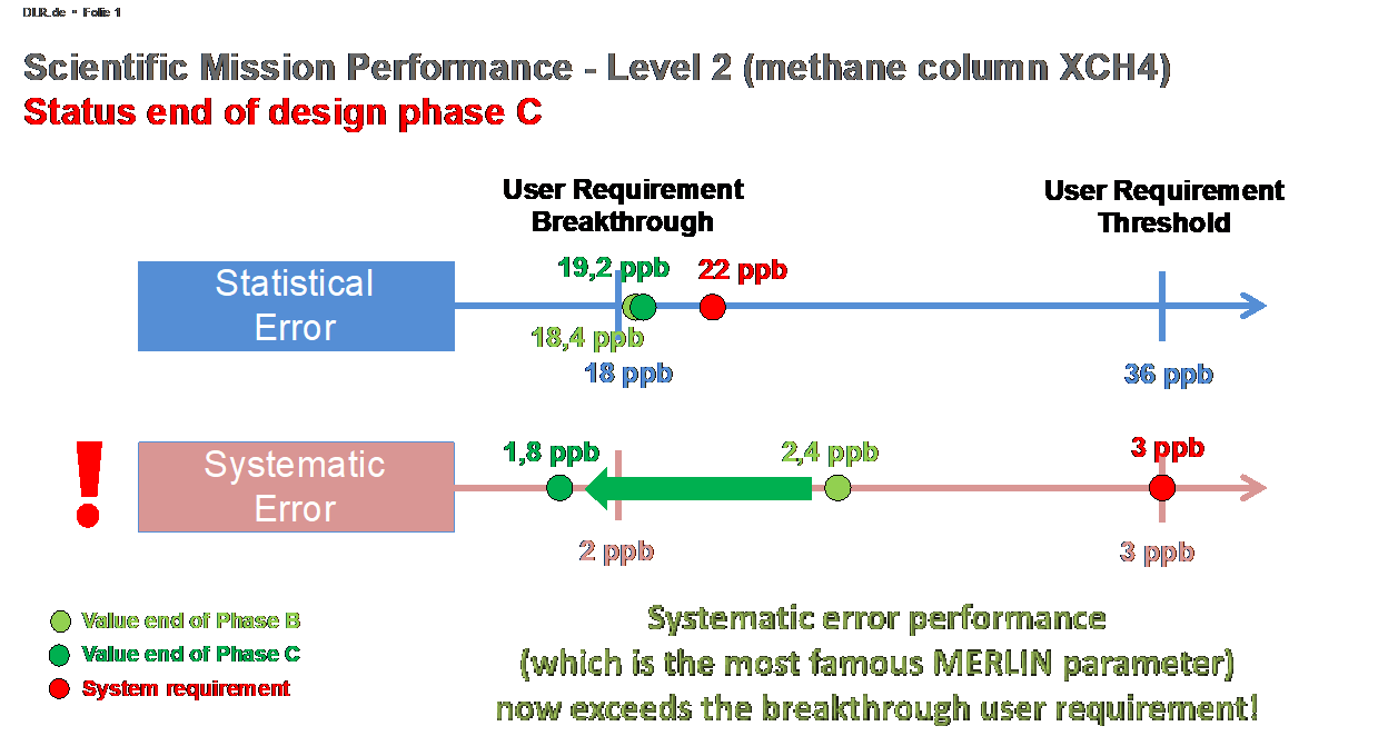
The main scientific objective of the MERLIN mission is to reduce uncertainties on CH4 sources and sinks, from global to regional scales. This is done through atmospheric flux inversions, using the information on atmospheric CH4 columns (L2 product: XCH4) provided by MERLIN. To be confident in these uncertainty estimations, a multi-model assessment is necessary accounting for the full error budget for L2 XCH4, including both random and systematic errors.

Random error
The main part of the random error depends on the geophysical situation: It is mainly related to the surface reflectivity and to the aerosol load, which directly relates to the signal strength, and secondly to the surface pressure and other elements with minor impact (e.g., slope of terrain, CH4 concentration, solar elevation angle, etc.). The performances are given in the Table for a typical reference scene with reflectivity 0.1 sr−1, a median aerosol load, and a SSE (related to surface pressure) of 300 m, which corresponds to median altitude over land. The scene is comparable with a typical vegetation surface. Low performance are expected for sea and snow areas, where the 50 km random error might reach 50 to 100 ppb. In that case, the random error can be reduced by further averaging.
| Parameter | Random Error | Impact on XCH4 |
| Differential Atmospheric Optical Depth (DAOD) | 1.3% | 23.14 ppb |
| SSE | 10 m | 2.57 ppb |
| Surface pressure (Numerical Weather Prediction (NWP)) | 2 hPa | 4.27 ppb |
| Temperature | 2 K | 5.2 ppb |
| Total budget based on specified values | 24.3 ppb |
Total budget for XCH4 random error obtained by combining specified values for contributors. The current best estimate of the budget (24.3 ppb) is compliant when accounting for the actual weighting function with enhanced sensitivity in the boundary layer (27 ppb).
Systematic error
For the systematic error, the situation is rather different than for the random error. As shown in the below Table, there are many contributors, which have roughly the same magnitude:
- the DAOD measured by the payload
- the error on the surface pressure
- the error on the weighting function
The first one is caused by the limited variations of the on/off ratio between the atmospheric and the internal calibration path, and by the still unknown residual of non-linearity after the correction of the detector. The second comes from both, the uncertainty of NWP products and the error of SSE estimation. Regarding the third contributor, the cross-section knowledge depends on external parameters, but also of the lidar itself, through the knowledge of the emitted frequency. As outlined in the Observation section, the “online” frequency has been chosen to be in a local minimum of the CH4 manifold in order to reduce the sensitivity to laser stability. Thus, the residual frequency error resulting from FRU measured frequency and the Doppler effect is almost negligible. For the error arising from the use of humidity profiles obtained from NWP, an optimal position of the offline wavelength guarantees a minor impact, due to compensating effects between the error impact on the water vapor DAOD corrective term and on the weighting function. Finally, the processing itself may contribute to the systematic error through the introduction of scene-dependent biases, for example in the horizontal averaging step.
| Parameter | Systematic errors | Impact on XCH4 |
| DAOD | 0.13% | 2.31 ppb |
| SSE | 6 m | 1.54 ppb |
| Surface pressure (NWP) | 0.2 hPa | 0.43 ppb |
| Temperature | 2 profiles of bias | 0.5 ppb |
| Water vapor | 4% | 0.1 ppb |
| Methane cross section | 0.2% | 0.62 ppb |
| Frequency | 7 MHz offset, 8 MHz systematic | 0.3 ppb |
| Laser width knowledge | 5% for 100 MHz | 0.17 ppb |
| Spectral purity | – | 0.23 ppb |
| Processing | 1 ppb | |
| Total budget based on specified values | 3.1 ppb |
Total budget for XCH4 systematic error obtained by combining specified values for contributors. The current best estimate of the budget (3.1 ppb) is compliant to the observational requirements when accounting for the actual weighting function with enhanced sensitivity in the boundary layer (3.7 ppb).


